A supremely high proportion of the greatest cartographers in history—reaching 100% after 1400—were Western. The history of cartography may indeed provide a window into what the German philosopher G.W.F. Hegel (1770–1831) called the “principle of the European mind…which is confident that for it there can be no insuperable barrier and which therefore takes an interest in everything in order to become present to itself therein…to make this Other confronting him his own, to bring to view the genus, law, universal, thought, the inner rationality, in the particular forms of the world. As in the theoretical, so too in the practical, the European mind…subdues the outer world to its ends with an energy which has ensured for it the mastery of the world.”
Chinese Cartography
While China did have a tradition of map-making, and did originate the rectangular grid system, most of its maps were lost, and a flat earth conception was at the basis of its cartography, whereas a spherical earth was at the basis of Western cartography from its origins in ancient Greece. Joseph Needham’s monumental 15 volume work, Science and Civilisation in China, contains a section on Chinese cartography, making the case that after the great ancient Greek cartographer named Ptolemy (100-178), scientific cartography “was unknown to Europeans” until about 1400 when they rediscovered Ptolemy’s writings, whereas the Chinese developed their own “scientific” tradition steadily from ancient times until they started copying the West after the arrival of the Jesuits. He has to acknowledge, however, that the Chinese had no conception of the determination of the size and curvature of the earth, and that a flat earth conception underpinned Chinese cartography. He persuasively argues that the “rectangular grid system” was “certainly” as old as Pei Xiu’s maps (224- 271 AD). He identifies Hsiu as “the father of scientific cartography in China”. Hsiu may rightfully be acknowledged as one of the “greatest cartographers” for his grid way of “depicting the correct relations between the various parts of the map,” and for his “method of fixing the lengths of derived distances from right-angled triangles”—as Chen Cheng-siang argues.
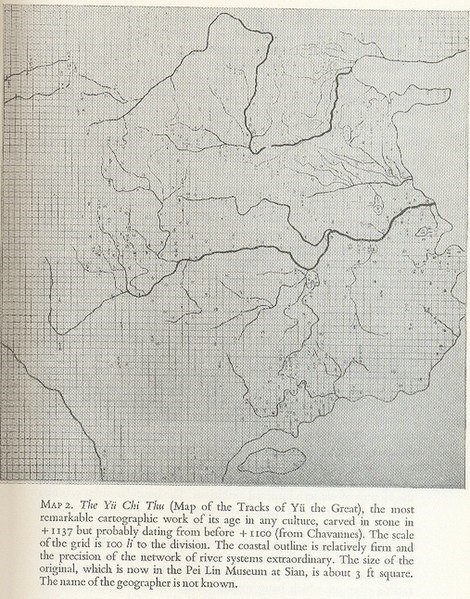
Needham and Chen bring up many other cartographers, and allude to many cartographic books and maps. But many of these books and maps were lost, so they rely instead on references to these maps and cartographers in other publications that seem to be bureaucratic reports. Reading the article by Chen Cheng-siang, “The historical development of cartography in China,” the impression I get is that improvements after Pei Xiu consisted in more precise grids, a greater quantity of maps with “a greater variety of alien lands and of frontier areas,” though many of the maps are heavily pictorial in their drawings of mountains, rivers, irrigation projects, cities, and palaces. I have yet to see a map from China superior to the famous Yu Ji Tu map of 1137 AD, which is quite remarkable.
It is hard to accept without some qualifications Needham’s judgment that China cultivated a “scientific” tradition in cartography when it had no conception of the sphericity of the earth, no determination of the size of the earth, no coherent and systematic integration of geography and cartography, no idea how crucial it is to have a conception, in the words of Ptolemy, of the “known habitable earth as a unit in itself” to draw maps to scale, and no systematic integration of astronomy and cartography and how important astronomical measurements of latitudes and longitudes are for finding unknown distances.
Ptolemy
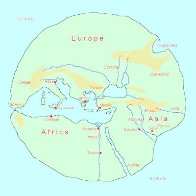
Claudius Ptolemy (100–170 AD) was the greatest cartographer in history before Geraldus Mercator came along in the sixteenth century. He was the culmination of a tradition of Greek cartography (combined with geography, astronomy and mathematics) going back to Hecataeus (550–476 BC), Pytheas of Massalia (350–306 BC), Eratosthenes (276-196 BC), and Hipparchus (190–120 BC). In the book Journey Round the World by Hecataeus, based on his extensive travels ending at the Atlantic coast of Morocco following the coast of the Mediterranean and Black Sea, and in his “World Map,” you see a mapping ambition to look outward beyond one’s place of birth in order to grasp the totality of the earth’s geography—notwithstanding its complete lack of a grid.
World Map of Hecataeus
This worldly view is enhanced in Pytheas’s book, On the Ocean, which recounts an amazing journey (ca. 310BC) northward to Brittany across the Channel into Cornwall, through the Baltic Sea, the coast of Norway, and even Iceland. While the Chinese retained their flat conception of the earth until the Jesuits taught them otherwise, way back in ancient times, Eratosthenes (276-185BC) contextualized the location of Europe in relation to the Atlantic and the North Sea, and calculated the spherical size of the earth within 5 percent of its true measure.
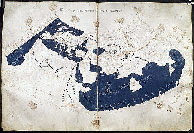
Then came Hipparchus, “the first to use the grade grid, and to insist that the map must be based only upon exact measurements of latitude and longitude,” to determine latitude from stellar measurements, rather than solar altitude, and to determine longitude by timings of lunar eclipses, rather than dead reckoning. Hipparchus also listed latitudes for several tens of localities and improved Eratosthenes’ values for the latitudes of Athens, Sicily, and southern extremity of India. But the consensus seems to be that Claudius Ptolemy (c. 85–165) deserves the honor of “father of cartography.” He was first to define the subject matter and explain that the key task of the cartographer is “to survey the whole world in its just proportions;” that is, to draw maps to scale. He realized that the “extent of our habitable earth from east to west…is much greater than its extent from the north pole to the south.” He was interested in mapping the whole earth, not just the habitable part, and to fit the earth into the scheme of the universe. He said, in fact, that cartography should be contrasted with what he called “chorography,” which merely consists in describing or mapping a region or district. Can we say that Chinese cartography was indeed chorography?
Ptolemy insisted (following in the footsteps of Hipparchus) that astronomy and mathematics were indispensable disciplines in the task of mapping the earth as accurately as the heavens had been charted. He was interested in the relationships between the earth and the sun and the earth and the moon. His treatise Analemma was a mathematical description of a sphere projected on a plane and a method for specifying the location of the sun. His work Planisphærium described a sphere projected on the equator, with the eye envisioned at the pole. His Almagest lay down the foundation of trigonometry and set forth his famous geocentric view of the universe. His Geographike hyphegesis was, in his words, “the geographical guide to the making of maps,” both of the whole inhabited world and of the Roman provinces, including the necessary topographic lists, and captions for the maps, and the nature of the materials and expertise mapmakers require. Ptolemy was well aware that he knew about only a quarter of the globe. This treatise was not superseded until the 16th century.
The Age of Discovery
Needham tells us that China “steadily” developed its scientific map-making tradition over the course of its history as the European map-making tradition “degenerated” after Ptolemy into “religious cosmography”. This is true: Ptolemy’s maps provided a more realistic and accurate cartographic view of the world than the so-called medieval mappa mundi, which were pictorial in showing coastal details, images of mountains, towns and provinces, as well as figures and stories from the Bible and classical mythology. On the other hand, Chinese cartography, as I noted above, did not really improve upon what Yu Ji Tu accomplished in his 1137 AD map. Its “flat earth” perspective persisted.
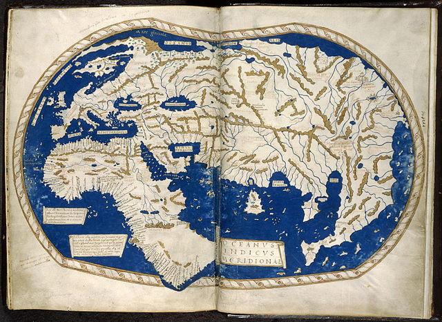
Meanwhile the marvelous European age of discovery would begin in the fifteenth century, preceded by the world eventful travels of Marco Polo (1254-1324), which found expression in the Catalan Atlas of 1375, a synthesis of medieval mappa mundi and the travel literature of the time, showing compass-lines, and a rather accurate delineation of the Mediterranean. The fourteenth century also saw the emergence of the mariner’s compass, which made it possible to determine from the location of a ship any coastal feature, harbor or island. We should acknowledge the Islamic contribution of the cartographer al-Idrisi, who produced a large planispheric silver relief map that was original in not portraying the Indian Ocean in a landlocked way and in offering a more precise knowledge of China’s eastern coast. But Islamic geography would go no further. The first real turning point leading directly to the sixteenth century cartographic revolution was the Portuguese planned discovery and mapping, under the leadership of Henry the Navigator, in the course of the fifteenth century, of the African West coast down to the southern tip of Africa, rounding this massive continent and finally uncovering the full extent of this “Terra incognita” or “unknown land”. A mere two years after Diaz had sailed around the Cape, Henricus Martellus created his World Map of 1490, which showed both the whole of Africa generally and the specific locations of numerous places across the African west coast, detailing the step-by-step advancement of the Portuguese.
Martellus World Map
Similarly, a few years after the discoveries of Columbus, Juan de la Casa produced the first world map in 1500 to include the New World. And in 1507 Martin Waldseemüller produced his Universalis cosmographia, identified as the first map to use the name “America” in honour of the Italian explorer Amerigo Vespucci. Waldseemüller was also the first to map South America as a continent separate from Asia, the first to create a printed wall map of Europe, and the first to emphasize the scientific importance of surveying and to use a forerunner to the theodolite, which he called the polimetrum, an optical instrument for measuring angles.
There were other European cartographers but none as great as Gerardus Mercator, who solved the perennial problem of how to translate the spherical Earth into the flatness of a map.
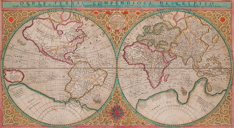
What Mercator realized, among other things beyond my expertise, is that to create a proper projection of the globe onto a flat surface “the spacing of the parallels of latitude would have to be made progressively larger away from the equator toward the poles” and that “the spreading of the parallels would have to be in exactly the same proportion as the spreading of the meridians”. Mercator was not a lone soldier; in 1570 Abraham Ortelius, though not a cartographer himself, published the first edition of Theatrum orbis terrarum, which incorporated seventy maps created by many cartographers.
Mapping in the Age of Modern Science
Once the age of discoveries intersected with the rise of modern science and the development of geodesy, which began as a surveying technique to determine with accuracy positions on Earth, which involved the invention of accurate measuring instruments and the development of new mathematical techniques, all of which happened in Europe, it stands to reason that all subsequent cartographers in history would be European. Some of the surveying tools and techniques which allowed for detailed hydrographic surveying of sea shores and islands, the topography of lands, heights of hills and mountains, included the general use of the plane table, for establishing and recording angles; the method of triangulation to determine distance of remote objects without going there; angle, distance, and elevation-measuring instruments…and John Harrison’s (1693-1776) ‘longitude’ clock, which finally solved the problem of determining longitude at sea.
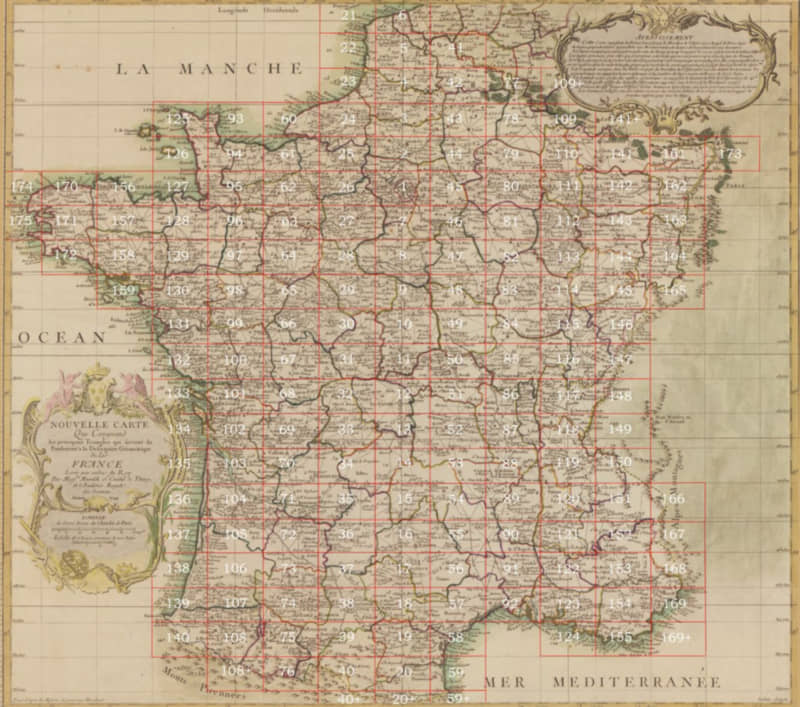
It is said that the Cassini family were the first to start mapping the interior of France, with César-François Cassini (1714-84) being the most illustrious in the utilization of new surveying tools such as triangulation and establishing that the Earth was flattened at the poles, and in the production of an accurate map of France.
James Cook (1728-1779) is best known as one of the greatest explorers ever, for his three voyages between 1768 and 1779 in the Pacific Ocean, reaching the southeastern coast of Australia for the first time in history, circumnavigating New Zealand, crossing the Antarctic Circle three times, and exploring the Northwest passage all the way to the Bering Strait. He embodied the Faustian spirit of exploration in its purest form, driven solely by a will to explore without economic self-interest or missionary zeal; confessing to an ambition which “leads me not only farther than any man has been before me, but as far as I think it possible for man to go.” What many don’t know is that Cook was also one of the greatest cartographers in history. His voyages were models of reconnaissance mapping. He produced the first hydrographic surveys of the coast of Newfoundland based on precise triangulation. He discovered New Zealand and mapped its entire coastline using the sextant, which measures the angular distance between two visible objects. He surveyed and mapped South Georgia. In his search of the Northwest Passage, he mapped the coast all the way to the Bering Strait. This is a kernel of what this man accomplished. Today he is disdained as a “colonizer” who did not discover anything because natives were already there—even though Cook exhibited “an entirely new civilized attitude towards the natives of the lands.”
There are too many great European cartographers to suppress. Francis Beaufort produced in 1792 the first map of Ireland, as the great hydrographer of his generation. He instructed map-making explorers that “the height of all headlands, isolated hills, and remarkable peaks should be trigonometrically determined…The nature of the shore, whether high cliff, low rock, or flat beach…the material of the beach, mud, sand, gravel or stones.” I won’t say anything about the men who started mapping the interior of India, and only a few words about the ones who began land surveying and mapping the United States. One has to start with Lewis and Clark, who conducted one of the most renowned journeys in history crossing the uncharted American West from August 1803 to September 1806, reporting in detail about the geography and wildlife, and producing about 140 maps of the area. They were followed by John Charles Frémont (1813-90), the first presidential Republican candidate, mapping explorer of the country between Missouri and the Rocky Mountains, Oregon and Upper California, and the “still and solitary grandeur” of the Great Salt Lake. Then there was Almon Harris Thompson, the mapper of Colorado through the Grand Canyon, southern Utah, part of Arizona—topographical maps to illustrate rivers, canyons, mountains, with a geological perspective.
Mappers of the bottom of the Ocean and the Universe
For all this, it has been estimated that in 1885 less than one-ninth of the land surface of the earth had been surveyed—which should not surprise us since the rest of the world remained asleep without much cartography other than the knowledge percolating from the West. In 1884, the West encouraged the world to adopt the Greenwich meridian dividing the Earth into the Eastern and the Western hemisphere, along an imaginary line of 0° longitude, establishing an International Date Line between one day and the next.
With the merger of the Western technologies of aviation and the camera, including aerial photogrammetry, cartography was revolutionized yet again, leading the to the rapid mapping of the globe through the 20th century. From this point on, we are no longer speaking of trailblazers as much as institutionalized cartographers assisted by scientists sitting on desks, who would go on to develop newer technologies, automation techniques, electronic distance-measuring instruments, inertial navigation systems, high resolution radars, remote sensing, and computers—revealing great geographic details at long distances. These technologies allowed radar imagery to be converted into maps of impenetrable regions like the Amazon, including geologic and seismic mapping of the earth beneath.
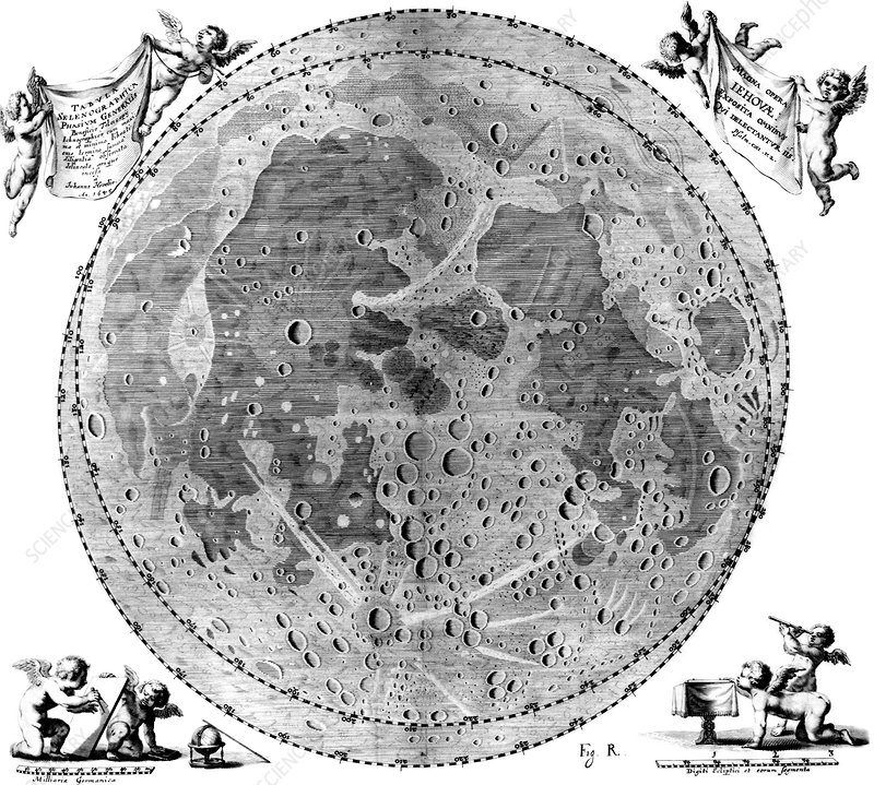
They also began to map the mountains, chasms, and plains beneath the oceans, with the use of deep-sea echo sounders, magnetometers, and underwater sonars. And the universe. Europeans had begun mapping the moon back in the seventeenth century, with the lunar cartographer Johannes Hevelius producing his famous Map of the Moon in 1647. Today, hundreds of teams of scientists are working with complex technologies, such as the Hubble and Spitzer Space Telescopes, mapping everything from the far reaches of the universe to the most infinitesimally small particles within it. This Faustian drive for mastery of the unknown has now produced (as of 2010), based on the ground-based telescopes of the 2MASS Redshift Survey, 3D images of 43,000 galaxies.
Our universities can’t meet the ideal of “higher learning” if they ignore and suppress the achievements of Western Civilization merely for the sake of inflating “the self-esteem of non-mainstream students.” Our commitment must always be to the truth in appreciation of what Isaiah Berlin called “the peaks, not the valleys, of the achievements of mankind.”
Ricardo Duchesne has also written on the creation of the university. He the author of The Uniqueness of Western Civilization, Faustian Man in a Multicultural Age, Canada in Decay: Mass Immigration, Diversity, and the Ethnocide of Euro-Canadians.
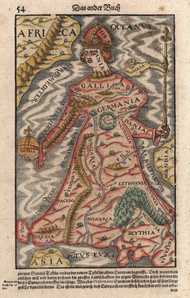
Featured image: “Europa regina,” printed by Sebastian Münster in Basel in 1570.